Friday, August 6, 2010
Desert Photography
http://cafe.themarker.com/topic/1706748/?utm_source=rss&utm_medium=feed&utm_campaign=default
Scroll down and flip through the pages to see all entries. Some really interesting images are participating.
Wednesday, April 28, 2010
Layered Networks


This is a Preliminary layered plan of the different infrastructural networks on the site. Still not pleased with it; I am trying to get the various networks more integrated with one another and with the site itself. Thinking that the form should emerge from mapping of the forces on site: rainfall, evaporation, gravity, existing habitats and their fluctuations, irradiation, circulation, economy etc. As well, I am still feeling that the connection between the infrastructural systems and the public realm is missing. The point is to have infrastructures that augment the living environment, not just run along it (or obliterate it altogether). Need to let the plans be and venture into 3D sections and models.
Friday, April 16, 2010
The Effective Terrain
In the current context of escalating climate catastrophes paralleled with depleting energy resources, degrading fresh water supplies and diminishing agricultural cultivating lands there is an increasing preoccupation with the prospects of a fast approaching global crisis. Arid regions, which under normal circumstances are places of acute extremes, are projected to be afflicted by these scarcities more profoundly. Since drylands are places in which survival hangs on a most fragile equilibrium any anomaly or scarcity can be detrimental the system’s viability. Alternatively, due to their unique ecosystem properties, not to be found in other more moderate environments, deserts can represent places of immeasurable potential for a prosperous subsistence.
The Negev desert which makes about two thirds of the land area of Israel is employed as a case study. The thesis investigation follows three narratives. FERTILE VISIONS explores the ethos of blooming the desert and the dangers inherent to realized utopias. EPHEMERAL FLOWS constructs a comprehensive framework of the Negev’s ecosystem, while mapping the operating forces and their affect on the system’s stability. VITAL SIGNS is a catalogue of strategies, systems and technologies in the fields of water management, solar energy and controlled environments. Their juxtaposition starts to suggest plausible hybrids.
Finally, EFFECTIVE TERRAINS defines design strategies for desert infrastructural systems. It envisions a prototype community planned through the synthetic interweaving of the existing Wadi Pharan ecosystem characteristics with water harvesting and purification, intensive solar energy generation and greenhouse agriculture production.
Saturday, April 3, 2010
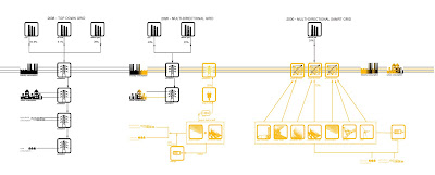
imagining the multi-directional grid
design guidelines
WATER-
1. Use existing topography and gravity forces.
2. Provide basins to capture runoff water from expansive catchment areas
3. Provide auxiliary reservoirs for water needs (both domestic and agricultural) for minimum 2 rain seasons.
4. Allow interconnectivity between reservoirs to optimize water availability (communicating vessels).
5. Take advantage of air born moisture (dew), rain collected from rooftops and reclaimed wastewater.
6. Invest in long term aquifer recharge- enhance water table by releasing cleansed water back to the wadi.
ENERGY-
1. Plan a system compatible with existing electrical grid, ready for incremental deployment
2. Select energy production technology according to site context, orientation, topography, community size, solar radiation available, climate data etc.
3. Allow for two way transmission- the inverted grid
4. Plan adequate storage for down times
5. Enable system modularity for future upgrades
6. Integrate smart grid capabilities: web communication, networking, monitoring and responsive feedback loops
CONTROLLED ENVIRONMENTS-
1. Study the physical and cultural context, in multiple scales
2. Acknowledge the limitations of the closed system- plan imports and exports to be in healthy equilibrium
3. Work with the site conditions and natural processes of the system
4. Encourage self organization and emergence patterns
5. Synthesize effective water, energy and agricultural systems with urban place making.
Saturday, February 27, 2010
systems catalogue


The following is an overview of strategies, systems and projects. These are used as precedents to inspire a compilation of design guidelines, for the synthesizing of water and solar infrastructures with controlled environments. This will form the bulk of chapter 3.


